


Brandenburg has a reputation for being flat, piney and predictable. Spend a few days on its hiking trails, however, and that stereotype dissolves into a landscape of glacial ravines, shimmering chains of lakes, remote heathland and some of the finest beech woods in central Europe. From short forest strolls that begin right at a Berlin S‑Bahn station to multi‑day routes crossing castle country, the region around the German capital rewards walkers who look beyond the city limits.
How Brandenburg’s Hiking Landscape Fits Together
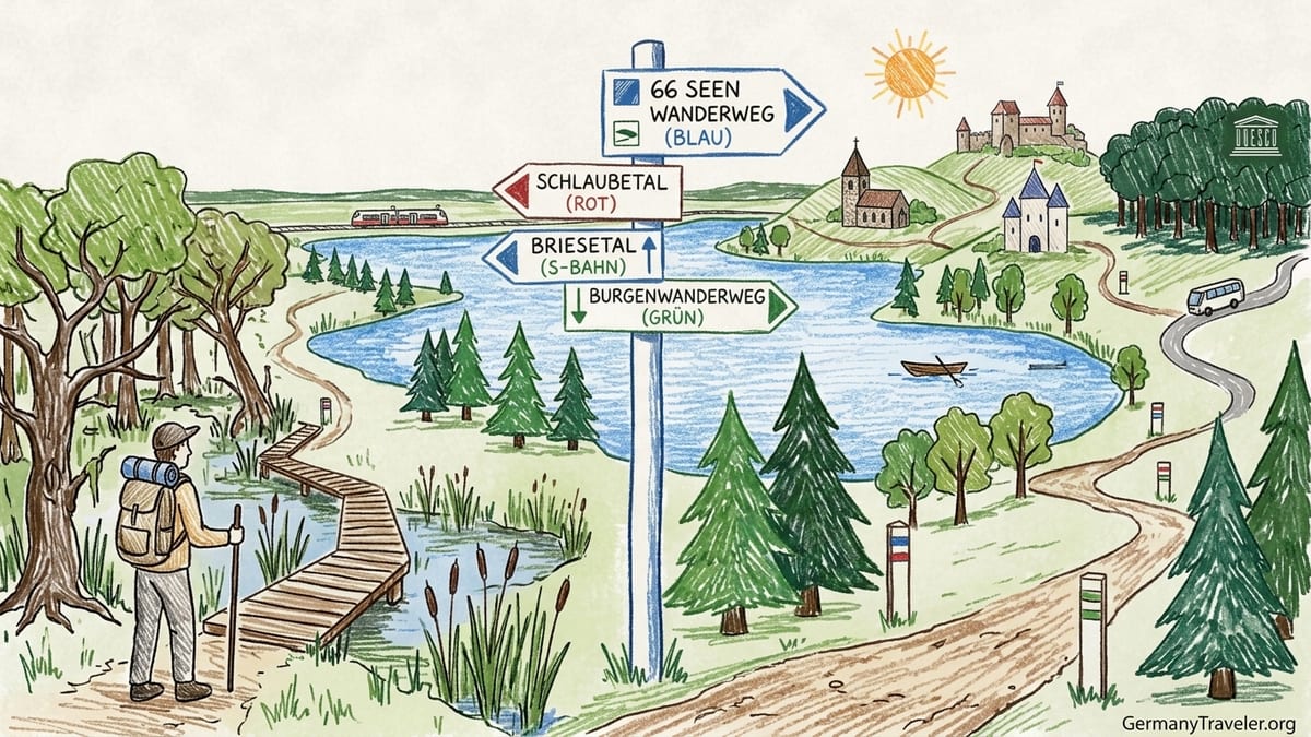
Brandenburg almost encircles Berlin, and many of its best hikes are within one to two hours by regional train. The terrain rarely feels alpine, yet the variety is striking once you compare the main routes. The 66‑Seen‑Wanderweg, or 66 Lakes Trail, is an approximately 425 kilometre circuit around Berlin in 21 stages that strings together lake‑dotted forests, canals and village landscapes starting and ending in Potsdam. In the southeast, the Schlaubetal‑Wanderweg follows a tumbling stream through one of the state’s deepest river valleys. North of the city, the Briesetal path offers swamp forest and raised boardwalks just a short S‑Bahn ride from Berlin.
Further out, the Märkische Schweiz region around Buckow concentrates short but often surprisingly rugged circuits in a pocket of hills and ravines formed by the last Ice Age. Southwest of Berlin, the Hoher Fläming rises as a low, rolling hill country of fieldstone churches and medieval castles, threaded by the Burgenwanderweg and Kunstwanderweg. To the north, the Schorfheide‑Chorin Biosphere Reserve and the Grumsin Beech Forest bring walkers into old‑growth beech stands and quiet lake basins with strict conservation rules and limited marked loops.
What unites these places is their accessibility and the waymarking culture that has built up over several decades. Long‑distance paths are usually signed with colored bars or symbols on trees and posts, and many official tourism agencies now publish GPX tracks that can be loaded into apps like Komoot or Outdooractive. Elevation gain is moderate on most routes, but glacial ravines, exposed roots, wetland boardwalks and loose sand can turn an apparently easy Brandenburg hike into unexpectedly demanding walking underfoot.
Because many trails cross protected nature parks and biosphere reserves, there are also important seasonal and environmental rules to understand. Some beech forests can only be entered on marked paths, dogs are often required to be leashed, and side tracks that look tempting on satellite imagery may in reality be closed to protect nesting birds or sensitive wetlands. Planning with up to date official maps and transport information is as important here as it would be for a mountain tour in the Alps.
The 66 Lakes Trail: Brandenburg in 21 Stages
The 66‑Seen‑Wanderweg is Brandenburg’s flagship long‑distance trail. Official descriptions put the circuit at roughly 416 to 425 kilometres, depending on variant and source, divided into 21 stages that can each be walked as a day tour. The route begins and ends in Potsdam and makes a wide loop around Berlin via places such as Hennigsdorf and Biesenthal in the north, Strausberg and Fürstenwalde in the east, Bad Saarow and Halbe in the southeast, and Trebbin in the south before closing the circle back to Potsdam. Tourism bodies in Brandenburg provide an overview map and GPX collection for all stages, as well as suggestions for combining them into multi‑day segments with overnight accommodation.
For visitors who do not wish to walk the entire circuit, the key advantage of the 66 Lakes Trail is its modular design. After a recent redivision of stages, the start and finish of each official section are aligned with regional train or bus stops. That means you can, for instance, catch a regional train from Berlin to Hennigsdorf, walk a lakeside and canal‑rich section toward Wensickendorf or Wensickendorf and backtrack on a different train line in the afternoon. Another example is the stage between Wendisch Rietz and Bad Saarow, which follows the shores of the Scharmützelsee and can be accessed from Berlin in roughly an hour by rail.
Elevation changes on the 66 Lakes Trail are usually modest, but across 20 to 25 kilometre stages they add up to a solid day out. The terrain ranges from comfortable forest tracks and village lanes to sandy heath paths, narrow lakeside roots and fragments of cobbled farm roads. Waymarking is generally with white and blue bars on trees or posts, but quality can vary; some walkers report that in sections around smaller villages or busy recreation zones it helps to have a GPX file open on a phone for confirmation. Water and food are very unevenly distributed. Stages that pass through tourist resort towns like Bad Saarow, Strausberg or Rheinsberg have bakeries, lakeside kiosks and supermarkets near the route, while long forested stretches such as those between Halbe and Groß Köris may have nothing more than a campsite snack bar in peak season.
Access from Berlin is straightforward because the route was explicitly planned as a series of public transport day hikes. Many stages begin and end at regional train stations such as Potsdam, Werneuchen, Oranienburg or Fürstenwalde. Ticket prices on regional trains fluctuate slightly, but as of late 2026 a Berlin to Potsdam single regional ticket typically costs under 5 euro when bought via the local transport association, while the Deutschlandticket offers nationwide regional travel for a fixed monthly fee. For shorter alternatives, you can split long stages into out‑and‑back walks from one station, or link only the scenic middle third of a stage by entering at a bus stop along the route and leaving at another. What you should not do is underestimate trail length; some “medium” difficulty lakeside stages exceed 20 kilometres and include long sandy stretches that can feel slow going.
Schlaubetal‑Wanderweg: Glacial Ravines and Old Mills
South‑east of Berlin, near the town of Müllrose in the Oder‑Spree district, the Schlaubetal‑Wanderweg concentrates some of Brandenburg’s most dramatic lowland scenery into a defined route of about 25 kilometres. Official descriptions from the regional tourism association and the German Hiking Association characterize it as a certified quality trail that follows the Schlaube stream upstream through the Schlaubetal Nature Park from Müllrose on the Großer Müllroser See to the area around Schlaubemühle and Wirchensee. The path threads deep, narrow ravines cut into the ground moraine, passes several historic water mills and skirts small lakes that fill kettle holes left by retreating glaciers.
The usual starting point is the lakeside town of Müllrose, which can be reached by regional bus from nearby Frankfurt (Oder). From here, the route climbs gently into mixed forest and then repeatedly descends steep, sometimes slippery slopes to rejoin the stream at footbridges and mills like Ragower Mühle. Total ascent figures from GPS sources often suggest around 400 to 500 metres of cumulative climbing over the full 25 kilometres, which, while never steep in alpine terms, can feel surprisingly energetic for Brandenburg. Waymarking uses specific trail symbols, but walkers should still watch out at junctions, especially where local circular routes share the same forest tracks.
Terrain is one of the Schlaubetal’s main challenges. Narrow singletrack runs right above the stream in several places, with roots and wet rocks that can turn hazardous after rain. Ravine descents are prone to mud in spring and autumn. In winter, shaded slopes can hold snow and ice, making trekking poles and boots with good grip highly advisable. The route is not uniformly family‑friendly: while older children used to hiking may enjoy the variety of bridges, mills and miniature gorges, some exposed side slopes and slippery steps are unsuitable for small children or pushchairs.
There are several shorter alternatives. The section between Ragower Mühle and Schlaubemühle includes many of the classic ravine views in a stretch of roughly 10 to 12 kilometres and can be walked as a loop by using different forest tracks back. At Wirchensee, marked circular paths of under 8 kilometres offer a taste of the valley without committing to the full distance. Water and food are available at seasonal restaurants or guesthouses around Müllrose and at some of the restored mill complexes, but there are long forest intervals with no services. Berlin visitors typically reach the area by regional train to Frankfurt (Oder) and then a local bus; combined travel time is often around ninety minutes to two hours each way, so starting early is essential if you want to complete the entire Schlaubetal route in one day.
Briesetal: Wetlands on the Edge of Berlin
If you want a forest and wetland hike with almost no logistical friction, the Briesetal north of Berlin is hard to beat. The protected valley of the small river Briese lies just beyond the city boundary between the S‑Bahn stations Borgsdorf and Birkenwerder, both served by Berlin’s S1 line. From Borgsdorf, signed paths lead toward the Kolonie Briese and into a mosaic of swamp forest, oxbow ponds and alder stands that feel surprisingly remote considering trains pass only a few kilometres away. The area forms part of the Barnim Nature Park and belongs largely to a designated habitat site, which is why most official routes keep close to established tracks and boardwalks.
One of the most popular options, promoted by regional tourism and nature park authorities, is a circular walk of roughly 12 to 15 kilometres that starts at S‑Bahn Borgsdorf, follows the Briese past the Waldschule Briese environmental education centre and small Briesesee, continues through increasingly wild stream meanders and then returns on a different forest line toward Birkenwerder. A shorter version of about 6 to 8 kilometres turns back near the Waldschule or the small sand beach often used by families in summer. The longer circuit includes sections of the 66 Lakes Trail, which also passes through here, and modest elevation changes when paths climb short morainic ridges beside the valley.
Terrain in the Briesetal is varied but rarely strenuous. Along the main valley runs a raised wooden plank path in some areas, the Briesetaler Steig, which allows you to cross boggy ground without trampling vegetation. In wet seasons, however, side paths can still be muddy and certain lower tracks may be temporarily closed by the forestry authorities due to flooding or storm damage. Tree roots, narrow boardwalks without railings and occasional fallen trunks across the trail mean that although families with outdoors‑savvy children walk here frequently, it should not be treated as a paved park promenade. Sturdy footwear is still recommended, especially in spring or after prolonged rain.
The practical strength of Briesetal is access and amenities. Both Borgsdorf and Birkenwerder have frequent S‑Bahn connections to central Berlin, with journey times from Friedrichstraße often under 35 minutes. Ticket costs fall within the Berlin ABC tariff zone, and many visitors use day passes or monthly tickets they already hold. There are cafés and bakeries around Birkenwerder station and, depending on season, a simple forest snack bar near the Waldschule Briese. Drinking water fountains are not guaranteed, so carrying sufficient water remains important even on a half‑day walk. Several alternative circuits are possible using signed local paths and the Berlin–Copenhagen cycle route, which runs near parts of the valley and offers wider gravel tracks as alternatives to the narrower streamside trails.
Märkische Schweiz: Pocket Mountains and Lakes
East of Berlin, the Märkische Schweiz Nature Park compresses hills, clear lakes and forest ravines into a relatively small area around the town of Buckow. Often described as Brandenburg’s “little Switzerland,” this landscape owes its character to terminal moraines stacked by several Ice Age advances. For hikers, this translates into short but surprisingly steep ups and downs, viewpoints above lakes like Schermützelsee and Kleine Tornowsee, and shady beech dips that feel a world away from the flat fields of the surrounding Oderbruch.
There is no single branded long‑distance hiking route here comparable to the 66 Lakes Trail, but instead a dense network of waymarked loops of 5 to 20 kilometres. Popular circuits start in Buckow, which can be reached by regional bus from Müncheberg station on the Berlin–Kostrzyn line. One classic loop of around 12 kilometres traces the shore of Schermützelsee before climbing up to viewpoints such as the Wurzelfichte area and returning via ravines around the Silberkehle and Wolfsschlucht. Another, slightly longer variant of about 17 kilometres adds quieter forest around the towns of Waldsieversdorf and Rehfelde, combining lakeside walking with stretches of open countryside.
The distinct appeal of Märkische Schweiz lies in the way a few hundred vertical metres of relief create constantly changing perspectives. Paths contour beneath beech and oak on narrow bench trails, then drop sharply on root‑strewn descents to dark pools and peat bogs. Some sections use narrow stepped paths cut into ravines, which can be slippery after rain and sometimes freeze in winter. Elevation gain on a typical 12 kilometre circuit might be around 250 to 300 metres, enough to leave you pleasantly tired at day’s end. Terrain is more uneven than many visitors expect from Brandenburg, so those with knee issues may wish to bring poles.
Waymarking is generally reliable, with colored symbols painted on trees and occasional information boards explaining geology and flora. Official nature park maps and GPX datasets are available from regional authorities and visitor centres in Buckow, and many routes are published in digital form in mainstream hiking apps. Water and food are concentrated in Buckow itself, which offers lakeside restaurants, ice cream stands and small supermarkets, especially busy in summer. Once you leave the town and its immediate bathing areas behind, services disappear; forest sections are unpopulated, and even in villages like Waldsieversdorf, seasonal cafés may be closed on weekdays outside school holidays. From Berlin, the typical connection involves an under one hour regional train ride to Müncheberg followed by a roughly 20 minute bus journey to Buckow, with Brandenburg’s day tickets or the Deutschlandticket covering both segments depending on tariff.
Hoher Fläming: Castles, Rummeln and Wide Horizons
Southwest of Berlin, the Hoher Fläming rises as a low hill chain rarely exceeding 200 metres in elevation but rich in cultural and natural history. The region’s signature multi‑day path is the Burgenwanderweg, a roughly 145 to 150 kilometre circuit designated by the German Hiking Association as a quality route. It runs in eight stages between about 14 and 25 kilometres, linking castles and forts such as Burg Eisenhardt in Bad Belzig, Burg Rabenstein, Burg Ziesar and Schloss Wiesenburg. Official nature park publications and the national tourist board both present the trail as a way to experience “Riesensteine, Rummeln und Ritterburgen,” or giant boulders, glacial ravines and medieval castles, across an historically farmed landscape.
The Burgenwanderweg is typically walked as a multi‑day tour, but like the 66 Lakes Trail it can easily be broken into individual day hikes using regional trains. Bad Belzig and Wiesenburg both lie on the rail line between Berlin and Dessau, with journey times from the capital often around 60 to 80 minutes. From Bad Belzig, one attractive day stage of around 18 kilometres heads south via open fields and mixed forest to Raben with its prominent castle, while another between Wiesenburg and Bad Belzig combines parkland, fieldstone villages and stretches of beech forest. Elevation gain per stage rarely exceeds 300 metres, but repeated short climbs out of “Rummeln” ravines can be tiring in warm weather.
Terrain alternates between sandy forest rides, grassy field margins, cobbled farm tracks and narrow ravine paths. In dry summers, wide sandy sections can feel like walking on a beach, slowing progress considerably; after heavy rain, the same hollows turn muddy. Some ravines contain exposed roots and eroded steps that demand careful foot placement. Because many stages use unsurfaced agricultural tracks, strong winds can be an issue across open fields, especially in shoulder seasons when there is little crop cover. Families with active older children often enjoy half‑stages focused on castle visits, but certain longer or more remote stretches of the Burgenwanderweg are better suited to experienced walkers who are comfortable navigating with a map in landscape with few landmarks.
Waymarking of the Burgenwanderweg and the related Kunstwanderweg, which links art installations between Wiesenburg and Bad Belzig, is generally solid, using distinctive symbols and information boards. The nature park publishes a “Wanderfibel” brochure with stage descriptions and GPX links, and GPX tracks are also widely available via route platforms. Water and food are typically found at stage endpoints such as Bad Belzig, Wiesenburg, Niemegk or Raben, where bakeries, guesthouses and sometimes castles themselves operate cafés. In between, services can be sparse, so carrying snacks and at least one to two litres of water is advisable even in cooler months. From Berlin, many hikers use the Deutschlandticket or regional day offers to keep costs manageable, turning single stages into full‑day excursions with a castle visit and dinner before returning to the city in the evening.
Schorfheide‑Chorin and Grumsin Beech Forest: Primeval Canopies
North of Berlin, the Schorfheide‑Chorin Biosphere Reserve and the Grumsin Beech Forest present a different side of Brandenburg, one defined by big‑scale forest blocks, quiet lakes and strict conservation. Parts of the beech stands near Grumsin form one of several German components of the UNESCO World Heritage listing that protects ancient and primeval beech forests across Europe. The result is a network of designated hiking routes that aim to bring visitors close to old‑growth scenery while keeping the most sensitive cores free from trampling and disturbance.
Around the village of Grumsin and the small town of Angermünde, several waymarked loops of roughly 8 to 20 kilometres circle and penetrate the buffer zones of the beech forest. One common route, often referred to as a Grumsin circular hike, runs for about 12 to 14 kilometres through rolling beech and mixed forest, crossing small glacial hollows and viewing points into core areas where human access is prohibited. Elevation gain is modest but constant as the path repeatedly climbs low ridges and descends to damp hollows. Trail surfaces alternate between soft forest soil, leaf‑covered singletrack and segments of sandy track or gravel forestry roads.
Because of the area’s protection status, conservation rules are particularly strict. Walkers must stay on marked paths, and side trails that might appear clearly trodden are often unofficial and off‑limits. Dogs must be leashed, and cycling is restricted to designated routes. Seasonal access limitations can apply during periods of high fire risk or to protect wildlife; local information boards and the biosphere administration provide updates, and it is wise to check these before traveling. For this reason, GPX tracks from official or partner organisations are more reliable than unverified user‑generated routes when planning a beech forest walk.
Schorfheide‑Chorin as a whole offers broader variety. Around the Chorin Abbey and lakes such as Werbellinsee, you find well‑established trails of 10 to 20 kilometres that combine cultural stops with long forest stretches. Paths often run right along lake shores on narrow strips of land, with roots and sometimes erosion on the water side. After heavy rain or in spring thaw, low lying sections beside bogs can be extremely muddy, and boardwalks are sometimes slippery. Elevation is modest, but repeated small climbs add up over a full day. Services cluster in villages like Althüttendorf or at tourist spots on Werbellinsee, where lakeside restaurants and boat rentals operate in summer; away from these nodes, the forest is largely unserviced.
From Berlin, access typically involves regional trains to Angermünde, Joachimsthal or Chorin, usually taking between 40 and 70 minutes, followed in some cases by local buses or a short taxi transfer to specific trailheads. Once again, regional transport passes make these day trips financially manageable, but you should expect quieter infrastructure than on trails closer to the capital. In exchange, you get some of the most atmospheric forest walking in Brandenburg, with cathedral‑like beech stands, rich birdlife and a sense of remoteness that seems hard to reconcile with the proximity of a major metropolis.
Planning, Safety and Seasonal Conditions
Across all these Brandenburg trails, a few recurring practical themes can make the difference between a rewarding day and a frustrating one. First is surface and weather. Although the region lacks high mountains, it has many sandy soils, peat bogs and glacial ravines that respond quickly to rain and meltwater. On the Schlaubetal‑Wanderweg and in Märkische Schweiz, slopes above streams can be slick with mud, while in Hoher Fläming and along the 66 Lakes Trail, wide sandy forest tracks can sap energy in dry spells. Roots hiding under leaves on beech slopes in Grumsin are a particular hazard in autumn. Sturdy footwear with grip is more important than ankle height; lightweight trail shoes with good soles are often sufficient in summer but may be cold and slippery in winter.
Second is waymarking and navigation. Brandenburg’s main branded routes are all waymarked, but signage density can vary due to storm damage, forestry work or simply aging markers. Having an offline capable map or GPX track from an official tourism portal or nature park site loaded into your phone or GPS device adds a reassuring backup. For example, if the 66 Lakes Trail’s white‑blue stripe disappears briefly at a village edge, a quick check against the GPX prevents a wrong turn that could add several kilometres. Paper maps from regional publishers remain available in tourist offices in places like Bad Belzig, Buckow or Müllrose for those who prefer analog navigation.
Water and food planning requires attention to the specific route. Close to Berlin, such as in Briesetal or the more urban sections of the 66 Lakes Trail, walkers can often top up water and find snacks at stations, kiosks or supermarkets. On more remote stretches in Hoher Fläming, Schorfheide‑Chorin or the central Schlaubetal, there may be no shops or restaurants for many hours. A common strategy is to have a substantial breakfast in the town where you disembark, buy picnic supplies in the local supermarket and then rely on a single café or guesthouse mid‑route if one exists. Many small rural businesses operate seasonally or close on certain weekdays, so relying entirely on a specific restaurant without checking opening times can leave you short of calories.
Finally, there are conservation and access points to respect. In Grumsin and parts of Schorfheide‑Chorin, entering core zones off the marked routes is prohibited. Around wetlands like Briesetal, leaving the boardwalks damages sensitive vegetation. Dogs are usually welcome but must be leashed, particularly in spring when ground‑nesting birds and deer offspring are vulnerable. Fire risk can lead to forest closures in hot, dry periods, especially on sandy pine plateaus; local forestry services and nature park administrations post notices in car parks and online, and regional media often report on high hazard levels. Treating these rules as part of the experience safeguards both nature and continued public access.
FAQ
Q1: What is the best first long‑distance trail in Brandenburg for visitors based in Berlin?
For many walkers, the 66 Lakes Trail is the most practical first choice because each of its roughly 21 stages begins and ends near public transport. You can sample one or two 15 to 25 kilometre sections as day trips without committing to the full 425 kilometre circuit, then decide later whether to link stages into a multi‑day tour.
Q2: Which hike offers the most dramatic scenery if I only have one day?
For dramatic lowland scenery, the Schlaubetal‑Wanderweg between Müllrose and Schlaubemühle or a ravine and lake circuit in Märkische Schweiz near Buckow are strong candidates. Both feature steep glacial valleys, narrow forest paths and picturesque waterways that feel surprisingly wild for Brandenburg, though they demand sure‑footedness and reasonable fitness.
Q3: Are any of these routes suitable for inexperienced hikers with children?
Shortened versions of the Briesetal walk between Borgsdorf and Birkenwerder and selected lakeside sections of the 66 Lakes Trail close to towns like Bad Saarow or Strausberg can work well for families with outdoors‑interested children. Parents should still be cautious around boardwalks without railings, steep riverbanks and rooty slopes, and pushchairs are usually impractical away from the widest forest roads.
Q4: Do I need specialized equipment to hike in Brandenburg?
For most of these routes, sturdy walking shoes with good grip, weather‑appropriate clothing, a small backpack and sufficient water are adequate. Trekking poles are helpful on steeper ravines in the Schlaubetal or Märkische Schweiz and on long sandy stretches in Hoher Fläming. In winter and early spring, waterproof footwear and additional warm layers are advisable due to mud and lingering snow or ice in shaded areas.
Q5: How can I find reliable GPX tracks for these hikes?
Official tourism websites for Brandenburg, regional nature parks and the German Hiking Association publish GPX tracks and stage descriptions for major routes such as the 66 Lakes Trail, the Schlaubetal‑Wanderweg and the Burgenwanderweg in Hoher Fläming. Many of these tracks are also curated in mainstream hiking apps, but it is wise to cross‑check that the digital route corresponds to current official recommendations and does not enter restricted conservation zones.
Q6: What is the easiest forest hike to reach from central Berlin by public transport?
Briesetal is among the easiest, as both Borgsdorf and Birkenwerder lie on the S‑Bahn network and can be reached from central stations like Friedrichstraße in under 35 minutes. From either station it takes only a short walk to enter the protected stream valley and join marked paths or boardwalks, making it ideal for a half‑day outing without complex planning.
Q7: Are there good options for multi‑day hut‑to‑hut style hiking in Brandenburg?
Traditional mountain huts are not common in Brandenburg, but multi‑day hiking is still possible by using guesthouses, small hotels and holiday rooms in towns and villages along routes. On the 66 Lakes Trail and the Burgenwanderweg in Hoher Fläming, walkers often plan two to five day itineraries, booking accommodation in stage towns like Bad Belzig, Wiesenburg, Buckow, Bad Saarow or Potsdam and carrying daypacks rather than full camping gear.
Q8: When is the best season for hiking these Brandenburg trails?
Spring and autumn are usually the most comfortable, with cooler temperatures, fewer insects and colorful foliage in beech forests such as Grumsin and Märkische Schweiz. Summer brings long daylight and swimming opportunities in lakes along the 66 Lakes Trail and elsewhere, but also heat, weekend crowds and occasional forest fire risk. In winter, many trails remain walkable, yet short days, ice on ravine paths and limited public transport schedules require extra caution and planning.
Q9: Can I combine hiking with cultural visits on these routes?
Yes, several routes lend themselves to combining nature and culture. The 66 Lakes Trail passes near Potsdam’s palaces and gardens, Schorfheide‑Chorin includes historic sites such as Chorin Abbey, and the Burgenwanderweg in Hoher Fläming is explicitly designed around castles and historic villages. Planning shorter hiking stages on those days allows time to visit museums, castles or abbey complexes without rushing.
Q10: Are wild camping and campfires allowed along these Brandenburg trails?
Wild camping is generally prohibited in Brandenburg’s nature parks and biosphere reserves, including areas like Schorfheide‑Chorin, Grumsin and Schlaubetal. Campfires are heavily restricted and often completely banned outside designated sites due to forest fire risk on sandy, pine‑covered soils. Hikers who wish to stay overnight should use official campsites, camping meadows or accommodation in towns and always check current fire regulations with local authorities before considering any open flame.